


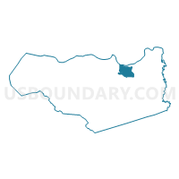
Voting District 54265, Contra Costa County, California
About
Outline

Summary
| Unique Area Identifier | 529892 |
| Name | Voting District 54265 |
| County | Contra Costa County |
| State | California |
| Area (square miles) | 11.25 |
| Land Area (square miles) | 10.97 |
| Water Area (square miles) | 0.28 |
| % of Land Area | 97.52 |
| % of Water Area | 2.48 |
| Latitude of the Internal Point | 37.99379750 |
| Longtitude of the Internal Point | -121.78469300 |
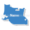
Maps


Graphs
Select a template below for downloading or customizing gragh for Voting District 54265, Contra Costa County, California


Neighbors
Neighoring Voting District (by Name) Neighboring Voting District on the Map
- Voting District 51753, Sacramento County, CA
- Voting District 54160, Contra Costa County, CA
- Voting District 54170, Contra Costa County, CA
- Voting District 54185, Contra Costa County, CA
- Voting District 54190, Contra Costa County, CA
- Voting District 54205, Contra Costa County, CA
- Voting District 54225, Contra Costa County, CA
- Voting District 54245, Contra Costa County, CA
- Voting District 54250, Contra Costa County, CA
- Voting District 54251, Contra Costa County, CA
- Voting District 54260, Contra Costa County, CA
- Voting District 54266, Contra Costa County, CA
- Voting District 54270, Contra Costa County, CA
- Voting District 54275, Contra Costa County, CA
- Voting District 54335, Contra Costa County, CA
- Voting District 54340, Contra Costa County, CA
- Voting District 54375, Contra Costa County, CA
- Voting District 54400, Contra Costa County, CA
Top 10 Neighboring County Subdivision (by Population) Neighboring County Subdivision on the Map
- Antioch-Pittsburg CCD, Contra Costa County, CA (149,665)
- East Contra Costa CCD, Contra Costa County, CA (119,315)
- Tassajara CCD, Contra Costa County, CA (57,964)
- Isleton CCD, Sacramento County, CA (5,291)
Top 10 Neighboring Place (by Population) Neighboring Place on the Map
Top 10 Neighboring Elementary School District (by Population) Neighboring Elementary School District on the Map
Top 10 Neighboring Secondary School District (by Population) Neighboring Secondary School District on the Map
Top 10 Neighboring Unified School District (by Population) Neighboring Unified School District on the Map
- Antioch Unified School District, CA (107,036)
- River Delta Joint Unified School District, CA (15,215)
Top 10 Neighboring State Legislative District Lower Chamber (by Population) Neighboring State Legislative District Lower Chamber on the Map
Top 10 Neighboring State Legislative District Upper Chamber (by Population) Neighboring State Legislative District Upper Chamber on the Map
Top 10 Neighboring 111th Congressional District (by Population) Neighboring 111th Congressional District on the Map
Top 10 Neighboring Census Tract (by Population) Neighboring Census Tract on the Map
- Census Tract 3551.08, Contra Costa County, CA (12,847)
- Census Tract 3020.10, Contra Costa County, CA (10,039)
- Census Tract 3032.01, Contra Costa County, CA (9,989)
- Census Tract 3080.01, Contra Costa County, CA (7,229)
- Census Tract 3050, Contra Costa County, CA (6,620)
- Census Tract 3072.05, Contra Costa County, CA (6,595)
- Census Tract 3551.09, Contra Costa County, CA (6,416)
- Census Tract 3551.11, Contra Costa County, CA (6,343)
- Census Tract 3020.09, Contra Costa County, CA (5,641)
- Census Tract 3551.07, Contra Costa County, CA (5,048)